Caravelí, the South Garden


Caravelí, Arequipa, Peru
Suggest Place to Visit
640
Track to location with GPS |
 |
This province was created by law No. 8004 of February 22, 1935, which divided the province of Camaná. The law does not specify the geographical reasons for its creation.
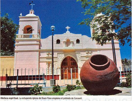
The Capital of the province is the city of Caravelí, elevated as Villa by law of November 9, 1839 and then to the category of city by law of September 2, 1870.
Many of its districts do not have a creation law, they are such since Independence and others in fact, such as the case of the district of Lomas, which was a hamlet of the district of Acarí, until October 1935, when aldermen were appointed for the District Council of Lomas. .
Known as The Garden of the South. The beautiful Caravelí, whose lands have been cataloged as the best wine-growing lands in the country, is a chest of surprises in the XXI century. The history of this province is recorded since the dawn of prehistory. The chronological antecedents take us to its coasts where the typical site of the fishermen's premises is located, in a place called Pullanca (Attic). Also to the world's largest ichthyopaleontological repository of whales, sharks, seals, megaterios, fossilized in the arid Sacaco desert (Bella Unión).
Pre-Hispanic and Inca cultures found this rich territory and settled. The Nazca culture made its domain until Camaná. Being Tambo Viejo (Acarí) contemporary with Cahuachi, capital of the Nazca, then sequentially the territory is occupied by the Waris, with clear influence in the Caravelí Valley, in the archaeological sites of Kukulí, Socospampa and Ananta.
The Peruvian Province of Caravelí is one of the eight that make up the Department of Arequipa, belonging to the Arequipa Region.
It limits to the north with the Ayacucho Region, to the east with the provinces of La Unión, Condesuyos and Camaná, to the south with the Pacific Ocean and to the west with the Ica Region.
Beaches
The northernmost beach in the Arequipa Region and Department is a continuation of the one that begins in Ica, with the name of Yanyarina. This beach full of birds is separated from the La Libertad spa by a hill that goes into the sea and which in turn is linked to a ledge with an islet, separated by a water channel. On the islet there is a stone that the local fishermen call ´´El Buda´´.
The La Libertad spa is formed by a curved sandy cove, where the sea is generally calm. This in turn is sheltered by Punta Sombrerillo. A small beach: El Buda, marks the beginning of the spa, which then continues with Lomo de Corvina and then, after a ledge presided over by a Cross, the spa itself appears, with a few houses.
The coast, towards the south, presents cliffs and inaccessible places, before reaching Cirilo Beach, which at its other end is flanked by ravines and alleys. In that area is the islet known as El Submarino or El Barco de los Pajaritos, due to the presence of guano birds.
Cliffs and a ledge follow, known as Las Tres Cuevas and Punta Pirata before Los Erizos beach appears, which is a sand curve, enclosed by a cliff:
El Cahuacho or Playa Grande, emerges next, heading south. It is wide, extensive and inhabited by birds. Another hill marks the end of this beach. From there you can see the islands of La Peninsula. This area (The Peninsula) is also known as Los Arcos. There are three large guano islets that form channels and whimsical shapes between them. Its presence marks the beginning of the Sombrerillo beach. A steep ledge that ends at the island of Hercules, divides the peaceful sea beach in two.
Isla Hercules is the end of a steep ledge. It is flat, tall and large and is connected to the shore by a neck of sand that forms two beaches.
At the end of these, an inaccessible islet inhabited by birds marks the beginning of the Mansa de Lomas beach. This is long, with a sloping shore and fine sand. Stains are extracted from it.
After a curve is the Punta Lomas beach, where bathers have ramadas and two hotels. On this beach is the old fishing port of Lomas.
In front of this port, the steam Pachitea (1915) was shipwrecked.
At ´´km 528´´ of the Panamericana Sur highway, an asphalt road leads to the port, which has houses built at the beginning of the 20th century, restaurants and a hotel. To the south there are canning and fishmeal factories.
Punta Lomas is a steep and high guanera area, in front of which is the Lobería islet, on which a lighthouse is installed, and therefore with restricted access.
Moving south is Brava de Lomas beach, which is large, with fine sand and large banks of machas. From there the dunes enter the continent, driven by the strong winds that come from the sea. The beach ends limited by Punta Peñueta.
This is a small chain of hills that go from the mainland to the sea.
In the past the area was known, especially by English cartographers, as Punta Paquija or Chaviña.
Playa Peñuelas, is small and limited by islets that are populated by sea lions and followed by several small sandy and rocky beaches.
Chaviña Beach, located to the south of the tip and cliffs, is sandy, with a rough and short sea. It is an area where there are vine plantations.
The town of Chaviña is crossed by the river of the same name, which previously bears the name of Acarí. On the shore is the mouth of the mighty Acarí River.
This channel marks the initial limit of the Yauca beach. This is a flat shore, rough sea and very strong winds that give rise to dunes that surround the houses of the town.
The various sectors of this beach, before the mouth of the Yauca River, are called El Muerto, Azabache and Media Luna beaches.
The mouth of the Yauca River has three branches that form the limit of the Boca Chica and La Pampama beaches.
El Morro Chala marks the limit of the Tanaca spa, famous for its wells between the cliffs. This nose is described in the chronicles of the seventeenth century. It is made up of the Cusihuamán and Cahuamarca peaks (1,297 meters above sea level) and a sand dune hill of 1,148 meters above sea level.
Black and reddish in color, Morro Chala forms a 25 km curve between Tanaca and Chala beach. In this Morro, furrowed by fresh water that allows the flowering of casuarinas and fig trees, there are pre-Columbian ruins and terraces, the only ones that are on the beach in Peru.
To the south are the pools of Tanaca. The cliffs begin with the Maucayata cove, with quiet wells and guaneros islets. In this area there are pre-Columbian ruins that could be used as granaries.
Continuing south, after passing large areas of grass and islets with sea lions and guano birds is the Silaca spa. This is inhabited in summer, ancestrally, by a family from Jaqui (25 km inland).
The Silaca spa has the appearance of a mountain town in the midst of ruins and terraces. There the pools have names such as: Los Hombres, Las Sirenas, Las Viejas,
Desembarcadero, by Piero, Los Curcos o Horobados, by La Cruz, Los Compadres, Brujillos, Vladimir and Los Pajaritos. Between Los Compadres and Brujillos is the Guanera point of Puerto Viejo, the Islote de Lobería, the ravine and islet of Santa Rosa and the cove of Ocopa.
To the south of the Los Pajaritos pool and the ravine where the Atiquipa River descends, is the Jihuay beach. On the same route is the former Moca spa. This pregnant with ruins and terraces is abandoned and is the twin of Silaca.
The last beach of Morro Chala is Puerto Inca, which until the beginning of the s. XX was known as Llacpatera. There are Inca ruins and an Inca trail that leads to Cusco (Qosqo = ´´Navel of the world´´).
Puerto Inca is at the height of ´´km 603´´ of the South Pan-American Highway and it is stated that the Inca took baths there.
Bahía de Chala is a large sandy beach, located south of Puerto Inca. This has three sectors known as: Aguadita, La Calera and Playa Grande or Playa Hermosa.
From here, it is said, that the chasquis (messengers who covered long distances on the run, in very short times) brought fresh fish to Cusco.
Continuing south is Playa Chica, with a flat shore and calm sea. It has a traditional pier with islets in the vicinity as a natural breakwater. These islets join the Centinela hill where a lighthouse is located at its top.
On the route to the south is the wide beach La Rinconada or Huaccyaco, where the stains are on the edge of the sand. Passing the mouth of the Cháparra River is the Millo or Cháparra, Huasllaco and Huaranguillo or Tres Palos beaches.
Aguada de la Zorra beach presents Punta Saguas, located very close to a hill where there are pi
Comments
We don´t have yet any comments about:
Caravelí, the South Garden
Caravelí, the South Garden
Be the first to leave a comment as it is very important to inform other people
Outros locais a visitar
Within a radius of 20 km from:Caravelí, the South Garden
Unfortunately we do not have information on other places to visit in this area yet
Hotel reservation near Caravelí, the South Garden within a radius of 20 km
No results
Why to book with TOURISTISCHE ROUTEN
The best prices
Our partnerships with the world´s largest operators offer research on the best market prices.
More options
At Rotas Turisticos you can book the hotel, buy the air ticket, book the transfer from the airport to the hotel and vice versa, book the local excursions, rent the car, take travel insurance and consult the places to visit and where to go.
Holiday Tips & Destinations
Hundreds of holiday destinations with all the options that allow you to easily choose the destination that best suits your dream vacation.
TOURISTISCHE ROUTEN
Links
Follow us on social networks


